


2023-06-13_15h27m05_utgtrack-36275 vallon du ban

psesjs
User
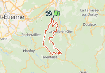

Length
24 km

Max alt
1133 m

Uphill gradient
824 m
Km-Effort
35 km

Min alt
626 m

Downhill gradient
828 m
Boucle
Yes
Creation date :
2023-06-13 13:27:05.902
Updated on :
2023-06-13 14:04:39.338
2h24
Difficulty : Difficult

FREE GPS app for hiking
 SityTrail
IGN / Geographical institutes
SityTrail Plus
The world is yours!
About
Trail Mountain bike of 24 km to be discovered at Auvergne-Rhône-Alpes, Loire, La Valla-en-Gier. This trail is proposed by psesjs.
Positioning
Country:
France
Region :
Auvergne-Rhône-Alpes
Department/Province :
Loire
Municipality :
La Valla-en-Gier
Location:
Unknown
Start:(Dec)
Start:(UTM)
617118 ; 5032315 (31T) N.
Comments